
🖍️Shop World Map Coloring Books –>

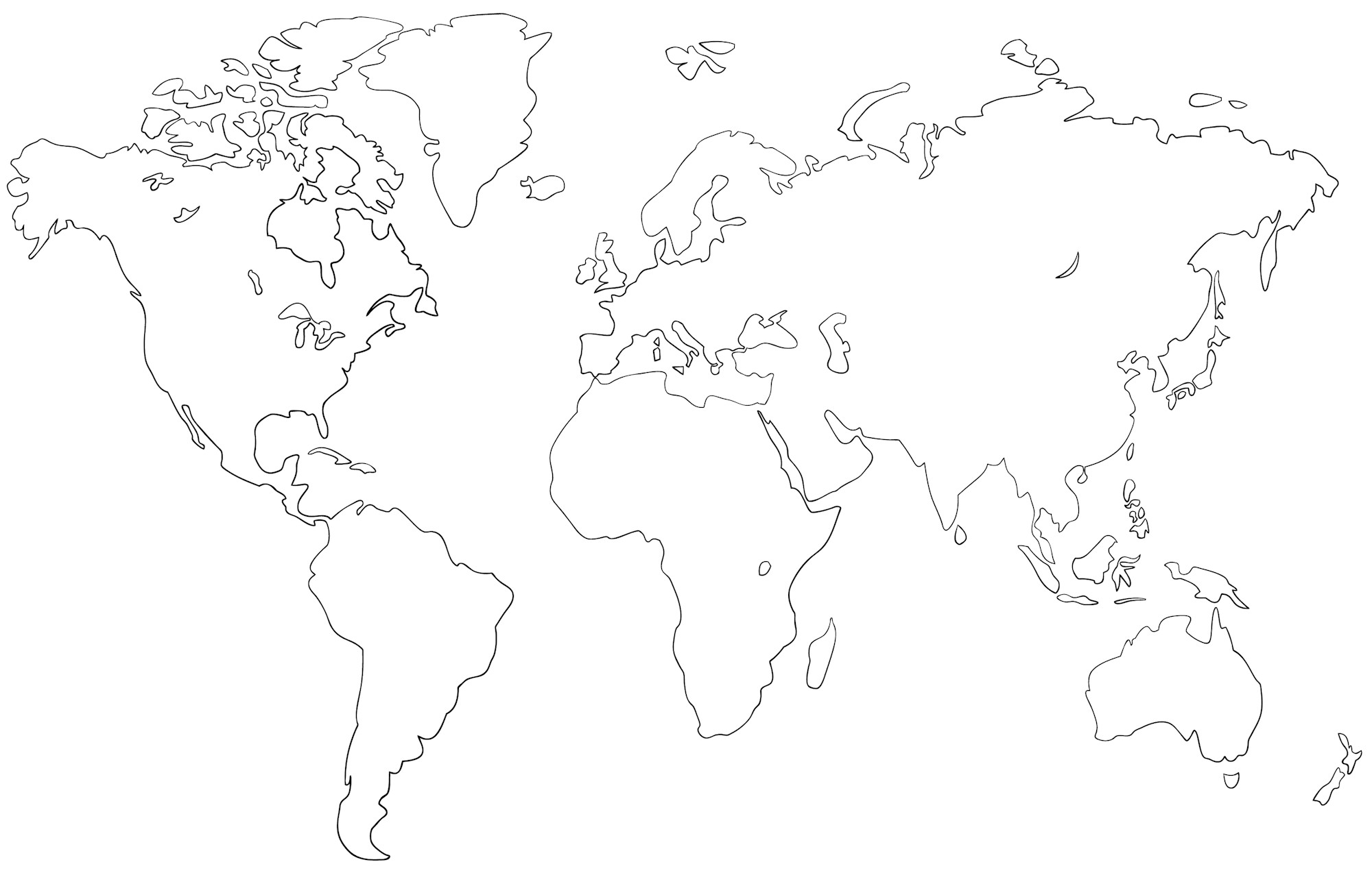
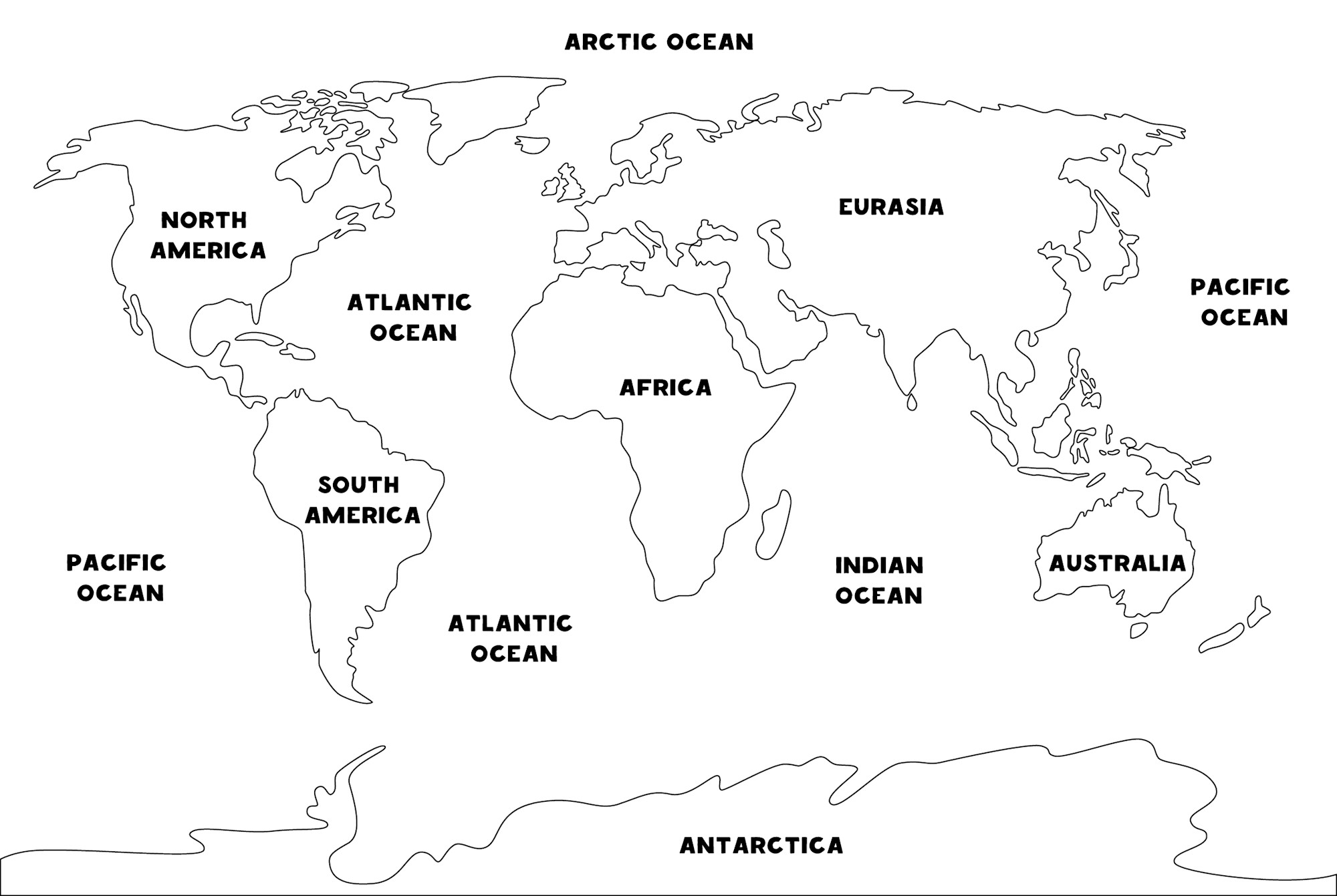
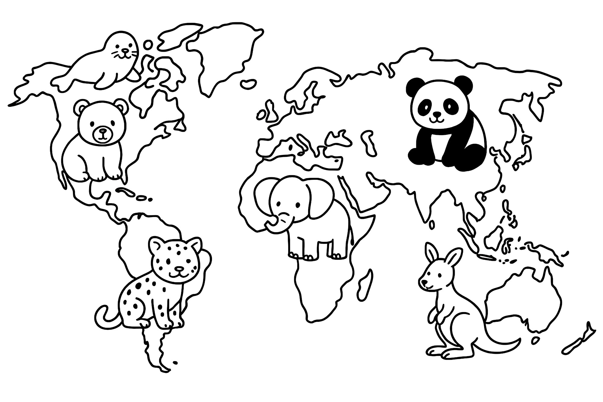
The whole world can fit on a coloring page.
Our World Map Coloring Pages turn continents, oceans, animals, and famous landmarks into creative printable activities for kids, classrooms, homeschool lessons, and anyone who enjoys exploring geography through art. Some of the maps are simple enough to use for learning the basic shapes of the continents, while others add animals or landmarks that invite a much bigger journey around the globe.
This collection includes a world map filled with animals, a map decorated with famous landmarks, simple world map outlines, and a cartoon-animal map designed especially for young colorists. Children can color just for fun or use the maps to practice identifying continents, oceans, directions, habitats, and places around the world.
Grab the crayons, colored pencils, or markers and get ready to travel the globe—without leaving the table.
🌎 Start With a World Map Coloring Page
A simple world map outline is one of the most flexible pages in the collection.
You can color every continent a different shade, use greens and browns for land and blue for water, or create an entirely imaginative planet covered in rainbow continents.
One easy approach is:
- North America — green
- South America — orange
- Europe — purple
- Africa — yellow
- Asia — red
- Australia — pink
- Antarctica — pale blue
These colors aren’t official, of course. They’re simply a way to make the continents easy to tell apart.
Children can also write the name of each continent directly on the map or add labels on small pieces of paper.
Once the land is colored, fill the oceans with different shades of blue or turquoise.
🗺️ Learn the Seven Continents
A world map is a natural place to begin learning the major land divisions of Earth.
In the seven-continent model commonly used in the United States, the continents are:
- Africa
- Antarctica
- Asia
- Australia
- Europe
- North America
- South America
Color each one differently and say its name aloud as you work.
Older children can try labeling the map without looking at another map first, then check their answers afterward.
Another activity is to start with one continent at a time. Color it, find it on a globe, and talk about one or two things associated with that part of the world.
There is no need to memorize everything in one coloring session. Geography becomes much easier when the world is explored piece by piece.
🌏 Australia or Oceania?
Children may sometimes encounter maps or school materials that use Oceania where another resource uses Australia.
That doesn’t necessarily mean one of the maps is simply wrong.
Different geographic traditions organize the world somewhat differently. National Geographic uses a seven-continent model in which Australia is the continent and Oceania is a broader geographic region associated with Australia and the many Pacific islands around it.
This is a good reminder that maps are tools humans create to represent the world, and the labels and conventions used can vary.
For a basic children’s coloring activity, following the labels on the map or the geography curriculum being used is usually the simplest approach.
🌊 Find the Five Oceans
Land isn’t the only thing worth coloring.
National Geographic recognizes five named oceans:
- Pacific Ocean
- Atlantic Ocean
- Indian Ocean
- Arctic Ocean
- Southern Ocean
Try finding each one on a reference map before adding labels to your coloring page.
The Pacific Ocean may appear on both the left and right edges of a flat world map because the real Earth is round. Those two areas are part of the same enormous ocean.
That can lead to an interesting question for kids:
Why does the Pacific seem to appear twice?
The answer is that a flat map has to choose somewhere to “cut” the globe when it represents a spherical planet on a rectangular sheet of paper.
🔵 Make Every Ocean a Different Blue
Instead of coloring every ocean exactly the same shade, experiment with a family of blues.
Try:
- Pale blue
- Aqua
- Turquoise
- Cobalt
- Navy
- Blue-green
The result can make the map more visually interesting.
Younger children may prefer one big blue ocean surrounding the continents, while older kids can label individual oceans and experiment with darker and lighter areas.
You can also draw waves, whales, fish, ships, or sea turtles in the open water.
For even more ocean creativity, explore our Under the Sea Coloring Pages and Coloring Pages of the Ocean.
🐘 Color a World Map Filled With Animals
One of the most playful pages in this collection fills the world map with animals.
This kind of picture is perfect for younger children because geography becomes connected with something they already enjoy: wildlife.
Look for animals on the map and color each one before working on the continents.
Then ask:
Where is the elephant?
Where is the panda?
Can you find an animal near Australia?
Which animals are shown near Africa?
Which creatures are near the ocean?
The illustrations are decorative rather than precise scientific range maps, so they shouldn’t be treated as exact representations of where species live. Instead, they can be used as conversation starters before looking at a real animal-range map or wildlife resource.
🐼 Match Animals With Parts of the World
After coloring the animal map, choose several animals and learn where they actually live in the wild.
For example, children might investigate:
- Elephants in Africa and Asia
- Giant pandas in China
- Kangaroos in Australia
- Zebras in Africa
- Tigers in Asia
- Penguins in the Southern Hemisphere
- Bears in several parts of the Northern Hemisphere
Then find those areas on the map.
Kids can draw an extra animal beside a continent after learning where it lives.
For even more animal coloring, visit our Coloring Pages of Zoo Animals or browse all of our Animal Coloring Pages.
🦓 Build a World Wildlife Map
The animal-themed page can become the beginning of a larger project.
Choose one animal for each continent and draw or paste it onto the map.
A simple version might include:
Africa: Zebra
Asia: Tiger
Australia: Koala
North America: Bear
South America: Sloth
Antarctica: Penguin
Europe: Fox
These are just examples, since continents contain enormously diverse wildlife.
Older children can research a specific species instead and mark a more accurate range.
The finished result becomes part coloring sheet, part wildlife project, and part geography map.
🏛️ Color a World Map With Famous Landmarks
Another page in the collection includes recognizable landmarks from around the world.
Landmark maps are especially fun because each illustration becomes the beginning of a new geography question.
What country is this landmark in?
What continent?
Is it ancient or modern?
Why is it famous?
Children don’t have to identify every structure before coloring. Start with the ones they recognize, then investigate one unfamiliar landmark at a time.
Use stone grays, brick reds, sandy browns, greens, blues, and gold—or make every landmark fantastically colorful.
✈️ Create a Pretend Around-the-World Trip
Once the landmark map is colored, use it to plan an imaginary trip.
Choose five places you’d like to visit.
Then number them:
- First stop
- Second stop
- Third stop
- Fourth stop
- Final stop
Draw a dotted line connecting them across the map.
Children can pretend they’re traveling by airplane, ship, train, or even hot-air balloon.
For each destination, add a little drawing of something you’d want to see, eat, photograph, or learn about.
The activity doesn’t have to become a realistic itinerary. It’s simply a playful way to think about where places are in relation to one another.
🧭 Add a Compass Rose
A map becomes even more useful when you understand direction.
Add a simple compass rose showing:
N — North
E — East
S — South
W — West
Then ask directional questions.
Which continent is south of Europe?
Which continent is north of South America?
Is Australia east or west of Africa on the map you’re using?
Where is Antarctica in relation to the other continents?
National Geographic suggests activities using compass roses to help children practice cardinal directions and map skills.
Kids can even design an elaborate compass rose with flowers, stars, arrows, or geometric patterns.
➡️ Practice North, South, East, and West
Once the compass rose is added, turn the coloring page into a direction game.
Try instructions such as:
Point to Africa. Move east. Which major landmass do you reach?
Find North America. Look south. Which continent is connected to it?
Find Antarctica. Which direction would you generally travel to reach the other continents?
You can also place a tiny star somewhere on the map and give clues that lead another person toward it.
This turns geography practice into a simple game rather than a worksheet.
🧠 Try a Blank Map Challenge
A world map outline with no labels can become a quick geography challenge.
Print two copies.
On the first map, use a reference and carefully label everything.
On the second map, see how much you remember without looking.
Try labeling:
- Seven continents
- Five oceans
- Equator
- North
- South
- East
- West
Older kids can add countries, mountain ranges, rivers, or other features as their geography knowledge grows.
Save the maps and repeat the activity a few months later. It’s fun to see how much more familiar the world becomes.
🖍️ Color-Code the Continents
Color coding can make a map easier to read.
Assign one shade to each continent and create a small key or legend at the bottom of the page.
For example:
🟢 North America
🟡 South America
🟣 Europe
🟠 Africa
🔴 Asia
🩷 Australia
🔵 Antarctica
A map legend explains what colors or symbols represent.
Children can invent their own legend instead of copying this example.
If the animal page includes symbols, the key might also show:
🐘 = Elephant
🐼 = Panda
🐧 = Penguin
Learning how legends work is one of the most practical map-reading skills children can practice.
🌐 Why Does a Flat World Map Look Different From a Globe?
Earth is roughly spherical, but a coloring page is flat.
That creates a problem: you cannot flatten the surface of a globe perfectly without stretching, compressing, or otherwise distorting some parts.
Cartographers solve this using different map projections.
That means the shapes and apparent sizes of continents may look somewhat different from one world map to another.
For younger children, the idea can be kept very simple:
A globe is round, but paper is flat, so mapmakers have to find different ways to show the round Earth on a flat page.
Compare your coloring page with a globe and see what differences you notice.
🌍 Turn the Map Into a Globe Activity
If you have a globe available, keep it beside the coloring page.
Choose a continent on the flat map and then find it on the globe.
Try the same with oceans.
You might notice that places that seem far apart on the edges of the paper map can actually be close together on the globe.
The Pacific Ocean is an excellent example.
Find Japan on one side and the west coast of North America on the other, then rotate the globe to see the ocean connecting them.
This makes the flat-map problem much easier to understand.
🏔️ Add Mountains to the Map
Once the basic continents are finished, older kids can add physical geography.
Draw small mountain symbols for famous ranges such as:
- Andes
- Rocky Mountains
- Himalayas
- Alps
Use triangles or little mountain peaks rather than trying to draw every range exactly.
Create another symbol in the map key explaining what the mountains mean.
This is a good next step for children who already know the continents and want a more challenging map project.
🌊 Add Rivers and Lakes
Blue pencils can do more than color oceans.
Older children can use a reference map to add several important rivers or lakes.
Start with just one or two rather than crowding the map.
The goal isn’t cartographic perfection. It’s learning that continents contain their own networks of water, mountains, forests, deserts, and other landscapes.
Kids could eventually create separate maps showing:
- Rivers
- Mountains
- Animals
- Climate
- Famous places
The same world outline can become a completely different geography project each time.
🌳 Make a Habitat Map
Instead of countries or landmarks, turn the map into a picture of Earth’s major habitats.
Use:
- Green for forests
- Yellow for grasslands
- Tan for deserts
- White for major ice-covered regions
- Blue for oceans
A real habitat map is much more complex than this, so treat it as a creative introduction rather than a scientifically precise map.
Then draw a few animals in the habitat where they live.
This activity pairs nicely with our Endangered Species Day Dice Game and Coloring Page, which can continue the conversation about wildlife and conservation.
🌊 Explore the Oceans
Because oceans cover such a large portion of a world map, they deserve more than one blue crayon.
After labeling the five oceans, pick one and learn about a creature that lives there.
Draw it onto the map.
You might add:
- Whale
- Dolphin
- Shark
- Sea turtle
- Octopus
- Jellyfish
Then continue underwater with our Under the Sea Coloring Pages.
A world map can become the cover page for an entire ocean coloring project.
🏖️ Find the World’s Coasts
Every continent except Antarctica contains places where people live near coastlines, and world maps make it easy to see how land and ocean meet.
Trace the coastline of one continent with a colored pencil.
Then choose another color and trace a second continent.
Kids may be surprised by how irregular coastlines are.
For another activity inspired by the places where land meets sea, explore our Coloring Pages of the Beach.
🎨 World Map Color Palette Ideas
Maps don’t have to use textbook colors.
Try one of these palettes.
🌍 Classic Geography
Green, brown, yellow, blue, and white.
🌈 Rainbow Continents
Red, orange, yellow, green, blue, purple, and pink.
🌊 Ocean World
Turquoise, teal, navy, sea green, sand, and cream.
🍬 Pastel Planet
Peach, lavender, mint, baby blue, pale pink, and yellow.
🌿 Earth Tones
Olive, rust, ochre, brown, cream, and blue-gray.
🌙 Night World
Navy, violet, turquoise, silver-gray, and black.
🎨 Bright Classroom
Red, yellow, green, blue, orange, purple, and pink.
Using a different shade for every continent can make labels easier to remember and help the shapes stand out.
🖍️ Choose Your Coloring Supplies
World maps work well with several different coloring tools.
Crayons are easy for younger kids coloring large continents and oceans.
Markers make individual continents stand out strongly, although fine tips are useful for maps with smaller islands and details.
Colored pencils give older kids more control around coastlines, animals, landmarks, and labels.
You can also combine them.
Try colored pencils for the land, crayons for the oceans, and markers for small landmark details.
If using markers on a printed page, place another sheet underneath in case the ink bleeds through.
✋ Practice Careful Coloring Around Coastlines
Map outlines include plenty of winding edges, islands, and narrow spaces.
Younger children don’t need to stay perfectly inside those boundaries, but older kids may enjoy trying to follow the coastlines carefully.
Start with large continents before moving to smaller shapes.
Using a sharpened colored pencil can help around narrow areas.
This type of coloring also gives children opportunities to practice controlling their art and writing tools while concentrating on a meaningful picture.
🔤 Practice Geography Words
World Map Coloring Pages naturally introduce useful geography vocabulary.
Write or practice words such as:
MAP
WORLD
GLOBE
CONTINENT
OCEAN
NORTH
SOUTH
EAST
WEST
EQUATOR
Older children can add latitude, longitude, hemisphere, and projection.
Don’t introduce everything at once. Choose the words that fit the child’s age and the activity you’re doing that day.
🌐 Find the Equator
The Equator is an imaginary line around Earth halfway between the North and South Poles.
Use a reference map to draw it across your coloring page.
Then notice which continents it crosses.
Color the Equator bright red or another contrasting shade so it’s easy to find.
You can also talk about the Northern Hemisphere and Southern Hemisphere.
The line doesn’t physically exist on Earth’s surface, of course. It’s a geographic tool people use to describe location.
🌓 Color the Northern and Southern Hemispheres
Print a simple outline map and try a two-color activity.
Use one color to lightly shade the Northern Hemisphere and another for the Southern Hemisphere.
Then mark the Equator between them.
Another map could focus on the Eastern and Western Hemispheres.
These concepts become easier to understand when children can see and color them rather than only hearing the vocabulary.
🏫 Easy World Map Activities for Classrooms
Printable world maps can work well for several classroom and homeschool activities.
Use them for:
- Continents and oceans lessons
- Geography centers
- Early-finisher activities
- Homeschool geography
- Animal habitat projects
- Landmark studies
- Map-reading practice
- Cardinal direction activities
- World-culture units
- Travel-themed projects
- Geography notebooks
The same map can be printed several times and used differently throughout the year.
One copy might show continents.
Another can show oceans.
Another can become an animal map.
Another might show places studied in history or literature.
📚 Follow a Story Around the World
A world map can also be paired with books.
Whenever a story takes place somewhere new, find that location on the map.
Mark it with a tiny star.
Over time, children can build a Books Around the World map showing all the places they’ve encountered through reading.
One color could represent fictional stories and another nonfiction.
The map slowly fills as the reading list grows.
✈️ Make a Travel Wish Map
Coloring doesn’t always have to be a formal geography lesson.
Use one map simply to mark places you’d love to see someday.
Add stars around countries, cities, landscapes, or landmarks that interest you.
Maybe your dream list includes:
- Mountains
- Tropical beaches
- Ancient ruins
- Famous cities
- National parks
- Islands
- Wildlife destinations
Draw a little airplane or dotted route between your choices.
The result becomes part coloring page and part dream board.
🧳 Create a Pretend Passport
Pair the world map with a homemade paper passport.
Choose one destination and make a page for it.
Include:
Place:
Continent:
Colors of the flag:
Something I’d like to see:
Something I’d like to learn:
Then move to another destination.
Children can add imaginary passport stamps after each coloring adventure.
It’s a playful way to encourage curiosity about places without pretending that one picture can represent an entire country or culture.
🌎 Explore Cultures With Curiosity
A world map may tempt us to reduce entire countries to one monument, food, animal, or costume, but real cultures are far more complex.
When an animal or landmark on the coloring page sparks curiosity, use it as the beginning of learning rather than the whole story.
Find reliable books, museum resources, maps, or educational websites created by knowledgeable organizations.
Ask:
Where is this place?
Who lives there?
What languages are spoken?
What landscapes are found there?
What would people who actually live there want visitors to understand?
Coloring can open the door. Learning can continue far beyond the page.
🐾 Create an Around-the-World Animal Book
Animal lovers can combine this map with several other Fun Free Coloring Pages collections.
Choose a few wildlife pages and organize them by region.
Start with our Coloring Pages of Zoo Animals, then add Coloring Pages of Elephants and Coloring Pages of Zebras.
Place the world map at the front.
Each time you color an animal, mark a broad part of its natural range on your map using a reliable wildlife source.
The coloring book gradually becomes a simple animal-geography project.
🌍 Explore the World One Color at a Time
These World Map Coloring Pages offer much more than a blank outline of Earth.
Color continents and oceans, meet animals from around the world, explore famous landmarks, practice directions, design map legends, compare a flat map with a globe, or create an imaginary trip that crosses several continents.
Younger children can simply enjoy filling the world with bright colors.
Older kids can add labels, research animals, mark the Equator, identify oceans, explore map projections, or turn one basic outline into several different geography projects.
There is no need to learn the whole world in one afternoon.
Start with one continent.
Find one ocean.
Color one animal.
Discover one place you didn’t know before.
Then come back another day and explore a little farther.
The world is enormous, but every journey begins somewhere—and this one can begin with a crayon.
Happy coloring and happy exploring!
🔗 Related Coloring Pages
- Under the Sea Coloring Pages
- Coloring Pages of the Ocean
- Coloring Pages of Zoo Animals
- Coloring Pages of Elephants
- Coloring Pages of Zebras
- Coloring Pages of the Beach
- Endangered Species Day Dice Game and Coloring Page
- Educational Coloring Pages
- Maps Coloring Pages
📚 Sources
- National Geographic — Continent
- National Geographic Society — National Geographic Map Policy
- National Geographic — Cardinal Directions and Maps
- National Geographic — Geography Standard 2: Mental Maps
🖍️Shop World Map Coloring Books –>